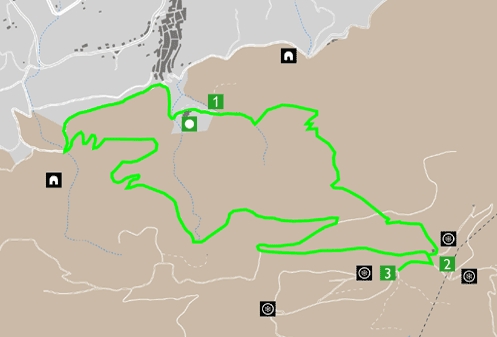
We start from the recreational area of the convent of Agres, which has stone and wood tables, a restaurant and a fountain. We will start the climb along the left bank from what we can see of the Barranc del Molí and the town of Agres with its characteristic physiognomy, sliding down the slope of the mountain. In a few meters we are at the very foot of the sanctuary (point 1). The path, steep enough at first, enters the village and shading Barranc de l’Assut, which joins downstream with the Barranc del Molí, where the dam was built, in order to regulate abundant flow . The path continues to rise, finding many crossings that have been opening for years; in order to avoid incipient erosion, we recommend always following the option of lower slope. We will cross the colonized slope by an interesting Mediterranean scrub with white pine. Little by little we will realize the captivating panorama that is emerging behind us. We will cross a forest track that leads to the ravine of the Teixera d’Agres, but we will continue upwards, continuing along the path until we reach the Montcabrer Refuge of the Alcoy Hiking Center (point 2), where the Cava del Yew (built in the 18th century), which goes virtually unnoticed because it is completely covered in ivy. At this altitude it will be easy to find the charismatic and prized sage of Mariola and the sharp blue piorno, well adapted to wind and frost. Crowning the summit of Molló del Teix, also known as Comptador, is located the watchtower. This point offers a privileged situation from where we can contemplate the colossal Montcabrer, the inner valleys of Mariola, the Recingle and the Cava Gran, the Valleta d’Agres and the counties of the Vall d’Albaida and the Coast, the Benicadell, the Beniarrés reservoir and the Safor in the background, Albureca, Almudaina, La Serrella and Aitana. To continue the route we will follow the forest track that descends in a south-westerly direction to the Cava Gran (also called Cava Arquejada) (point 3), Cava Grande or Arqueada, an unequivocal symbol of this mountain range. Built between the 17th and 18th centuries, it was in use until the beginning of the 16th century. XX, being used again punctually during the Civil War. It is 11 m. depth and 15 m. of inner diameter, with six Gothic-style arches pointed at the ends of the outer hexagon and joined in the center; this structure supported the vault of beam and reeds, finished off with Moorish tile. Inside you can see a vigorous yew tree. In this high sector of the mountain range, we find the priority habitat of many birds such as the crow, the blond terrier, the alpine acorn, the rare country tit; in addition to birds of prey such as the little grebe or the golden eagle. We will return on our steps to the Refuge and take the forest track that goes down to the left in a north-westerly direction, allowing us to contemplate at all times a landscape, no less anthropized less beautiful, with the valley of Agres and the mountains which enclose it on the horizon. Along the way we will find many species typical of the Mediterranean scrub with a shrub layer composed of juniper, coscoll, argelagues, rosemary, heather, matapoll, steppes and other smaller plants such as chamomile bark, rudder, and cat’s claw. , colonizing cracks and holes along the road. As we descend, we can find signs of a beech, fox, or wild boar. In the summer it is easier to find a reptile like the ladder snake. After several curves, the road passes through what is known in Agres as the Font del Tio Rufino, to end up crossing a paved track, which if we continue to the left (to the west), would lead us to the Molí Mató recreational area, where one of the best Valencian examples of vegetation associated with fountains and springs is preserved, on a bush of extraordinary dimensions. To return to the starting point, we turn right, reaching the first houses of the village and continuing along the path of the convent, flanked by monumental cypress trees that welcome us again, in front of the cavities known as La Cova of the Bulls.
In the shade of the cellars
Inicio |


